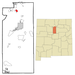
Pojoaque, New Mexico | |
|---|---|
 Location of Pojoaque, New Mexico. | |
| Coordinates: 35°53′26″N 106°0′34″W / 35.89056°N 106.00944°W | |
| Country | United States |
| State | New Mexico |
| County | Santa Fe |
| Area | |
| • Total | 4.37 sq mi (11.31 km2) |
| • Land | 4.37 sq mi (11.31 km2) |
| • Water | 0.00 sq mi (0.00 km2) |
| Elevation | 5,883 ft (1,793 m) |
| Population | |
| • Total | 2,071 |
| • Density | 474.13/sq mi (183.06/km2) |
| Time zone | UTC-7 (Mountain (MST)) |
| • Summer (DST) | UTC-6 (MDT) |
| ZIP code | 87506 |
| Area code | 505 |
| FIPS code | 35-58630 |
| GNIS feature ID | 2409085[2] |
Pojoaque (/pəˈwɑːkiː/; Tewa: Pʼohsųwæ̨geh Ówîngeh/P'osuwaege Owingeh [p’òhsũ̀wæ̃̀gè ʔówîŋgè]), Po’su wae geh, which translates to “water gathering place”,[4] is a unincorporated community in Santa Fe County, New Mexico, United States. It is part of the Santa Fe, New Mexico Metropolitan Statistical Area. The population was 1,907 at the 2010 census. For statistical purposes, the United States Census Bureau has defined Pojoaque as a census-designated place (CDP). Pojoaque Pueblo, a neighboring community, is an Indian reservation, and the town of Pojoaque is a collection of communities near the pueblo with people from various ethnic backgrounds. The area of Pojoaque includes the neighborhoods of Cuyamungue, Jacona, Jaconita, Nambé and El Rancho.
- ^ "ArcGIS REST Services Directory". United States Census Bureau. Retrieved October 12, 2022.
- ^ a b U.S. Geological Survey Geographic Names Information System: Pojoaque, New Mexico
- ^ Cite error: The named reference
USCensusDecennial2020CenPopScriptOnlywas invoked but never defined (see the help page). - ^ Pearce, T.M.,editor, New Mexico Place Names, A Geographical Dictionary, University of New Mexico Press 1965. ISBN 0-8263-0082-0
