This article may require cleanup to meet Wikipedia's quality standards. The specific problem is: remove original research, tone down POV. (August 2014) |
Poland | |
|---|---|
 | |
| Coordinates: 39°26′39″N 86°57′3″W / 39.44417°N 86.95083°W | |
| Country | United States |
| State | Indiana |
| County | Clay |
| Township | Cass |
| Elevation | 696 ft (212 m) |
| Time zone | UTC-5.0 (Eastern (EST)) |
| • Summer (DST) | UTC-4.0 (EDT) |
| ZIP codes | 47868 |
| Area code(s) | 765 and 812 |
| GNIS feature ID | 441396[1] |
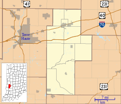
Poland is an unincorporated community in eastern Cass Township, Clay County, Indiana, United States. It lies along State Road 42 southeast of the city of Brazil, the county seat of Clay County.[2] Its elevation is 696 feet (212 m).[1] Although Poland is unincorporated, it has a post office, with the ZIP code of 47868.[3]
The zip code of 47868 has segments in three counties (Clay, Owen, and Putnam). Poland, Indiana is also in Owen County.
The 47868 ZIP Code is centered in Owen County at latitude 39.451 and longitude -86.975. It is a standard type ZIP Code. Owen County is in the Eastern Time Zone (UTC -5 hours) and observes daylight saving time.
ZIP Code Tabulation Area (ZCTA) 47868 has a land area of 58.11 sq. miles and a water area of 1.64 sq. miles for Census 2000.
- ^ a b "Poland, Indiana". Geographic Names Information System. United States Geological Survey, United States Department of the Interior. Retrieved June 1, 2008.
- ^ DeLorme. Indiana Atlas & Gazetteer. 3rd ed. Yarmouth: DeLorme, 2004, p. 43. ISBN 0-89933-319-2.
- ^ Zip Code Lookup
