This article includes a list of general references, but it lacks sufficient corresponding inline citations. (June 2014) |
| Polesie State Radioecological Reserve | |
|---|---|
| Палескі дзяржаўны радыяцыйна-экалагічны запаведнік (Belarusian) Полесский государственный радиационно-экологический заповедник (Russian) | |
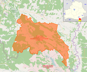
 OSM map of the reserve highlighting some nearby places in the annotations (as Mazyr, Pripyat, the Chernobyl Plant etc). The map in the corner shows its position (red) within Belarus, showing also the Ukrainian, and contiguous, Chernobyl Exclusion Zone (yellow) | |
 | |
| Location | Belarus |
| Nearest city | Brahin, Narowlya, Khoiniki |
| Coordinates | 51°39′N 29°59′E / 51.650°N 29.983°E |
| Area | 2,162 km2 (835 sq mi) |
| Established | July 18, 1988[1] |
| Official website | |
The Polesie State Radioecological Reserve (PSRER; Belarusian: Палескі дзяржаўны радыяцыйна-экалагічны запаведнік, romanized: Palyeski dzyarzhawny radyyatsyyna-ekalahichny zapavyednik; Russian: Полесский государственный радиационно-экологический заповедник, romanized: Polessky gosudarstvenny radiatsionno-ekologichesky zapovednik) is a radioecological nature reserve in the Polesie region of Belarus, which was created to enclose the territory of Belarus most affected by radioactive fallout from the Chernobyl disaster. The reserve adjoins the Chernobyl Exclusion Zone in Ukraine. The environmental monitoring and countermeasure agency, Bellesrad, oversees the agriculture and forestry in the area.
- ^ "Polesie State Radioecological Reserve: about". Archived from the original on 2014-06-22. Retrieved 2014-06-27.