| Pomeroy | |
|---|---|
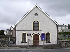
 Pomeroy Presbyterian Church | |
Location within Northern Ireland | |
| Population | 788 (2011 Census) |
| District | |
| County | |
| Country | Northern Ireland |
| Sovereign state | United Kingdom |
| Post town | Dungannon |
| Postcode district | BT70 |
| Dialling code | 028 |
| UK Parliament | |
| NI Assembly | |
Pomeroy is a small village and civil parish in County Tyrone, Northern Ireland. It is in the townland of Cavanakeeran,[2] about 8.5 miles (14 km) from Cookstown, 9 miles (14 km) from Dungannon and 16 miles (26 km) from Omagh. The 2011 Census recorded a population of 788 people.[3]
Pomeroy is atop a large hill that dominates the surrounding countryside. From the Cookstown end, the road through the village gradually climbs a gradient up to a village square, The Diamond. The village is surrounded by the Pomeroy Hills. The surrounding countryside is a mixture of moorland and bog land. Stone age and Bronze Age cairns dot the landscape. Pomeroy is the closest settlement to the geographical centre of Ulster.[4]
- ^ Too many names for Pomeroy Archived 8 June 2012 at the Wayback Machine Belfast Telegraph.
- ^ Ordnance Survey Ireland: Online map viewer (choose "historic" to see townland boundaries) Archived 29 August 2012 at the Wayback Machine
- ^ "Census 2011 Population Statistics for Pomeroy Settlement". Northern Ireland Statistics and Research Agency (NISRA). Archived from the original on 4 May 2021. Retrieved 4 May 2021.
 This article contains quotations from this source, which is available under the Open Government Licence v3.0 Archived 28 June 2017 at the Wayback Machine. © Crown copyright.
- ^ "Ireland Geographical Facts, Figures and Physical Extremities". Archived from the original on 19 December 2015. Retrieved 26 December 2015.
