Ponta Delgada | |
|---|---|
|
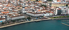
Top: view of Ponta Delgada; middle: Igreja de São Sebastião; City Hall; Convento da Esperança; bottom: City Gates of Ponta Delgada; Igreja de São José. | |
| Coordinates: 37°44′28″N 25°40′50″W / 37.74111°N 25.68056°W | |
| Country | |
| Auton. region | Azores |
| Island | São Miguel |
| Established | Settlement: c. 1450 Municipality: 2 April 1546 |
| Parishes | 24 |
| Government | |
| • President | Pedro Nascimento Cabral[1] |
| Area | |
• Total | 232.99 km2 (89.96 sq mi) |
| Highest elevation | 761 m (2,497 ft) |
| Lowest elevation | 0 m (0 ft) |
| Population (2021) | |
• Total | |
| Time zone | UTC−01:00 (AZOT) |
| • Summer (DST) | UTC+00:00 (AZOST) |
| Postal code | 9504-523 |
| Area code | 296 |
| Patron | Senhor Santo Cristo dos Milagres |
| Local holiday | Monday following the Sunday of festival of Senhor Santo Cristo |
Ponta Delgada (European Portuguese pronunciation: [ˈpõtɐ ðɛlˈɣaðɐ] ; lit. 'Thin Cape') is the largest municipality (concelho) and executive capital of the Autonomous Region of the Azores in Portugal. It is located on São Miguel Island, the largest and most populous in the archipelago. As of 2021, it has 67,287 inhabitants,[2] in an area of 232.99 square kilometres (89.96 square miles).[3] There are 17,629 residents in the three central civil parishes that comprise the historical city: São Pedro, São Sebastião, and São José.[4] Ponta Delgada became the region's administrative capital under the revised constitution of 1976; the judiciary and Catholic See remained in the historical capital of Angra do Heroísmo while the Legislative Assembly of the Azores was established in Horta.
- ^ "Composição e áreas do executivo". cm-pontadelgada.pt (in European Portuguese). Retrieved 10 November 2021.
- ^ "INE – Plataforma de divulgação dos Censos 2021 – Resultados Preliminares". censos.ine.pt. Retrieved 10 November 2021.
- ^ Eurostat Archived 7 October 2012 at the Wayback Machine
- ^ Instituto Nacional de Estatística


