Porcupine, South Dakota
pȟahíŋ siŋté | |
|---|---|
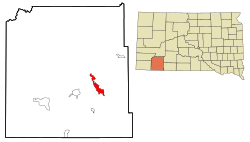
 Location in Oglala Lakota County and the state of South Dakota | |
| Coordinates: 43°16′07″N 102°20′07″W / 43.26861°N 102.33528°W | |
| Country | United States |
| State | South Dakota |
| County | Oglala Lakota |
| Area | |
| • Total | 9.59 sq mi (24.83 km2) |
| • Land | 9.59 sq mi (24.83 km2) |
| • Water | 0.00 sq mi (0.00 km2) |
| Elevation | 3,288 ft (1,002 m) |
| Population | |
| • Total | 925 |
| • Density | 96.48/sq mi (37.25/km2) |
| Time zone | UTC−7 (Mountain (MST)) |
| • Summer (DST) | UTC−6 (MDT) |
| ZIP code | 57772 |
| Area code | 605 |
| FIPS code | 46-51340[4] |
| GNIS feature ID | 2393194[2] |
Porcupine (Lakota: pȟahíŋ siŋté; "porcupine tail") is a census-designated place (CDP) in Oglala Lakota County, South Dakota, United States. The population was 925 at the 2020 census.[5]
The community most likely was named after Porcupine Butte.[6] Porcupine has been noted for its unusual place name,[7] and for its designation as the unofficial capital of the unrecognized Republic of Lakotah.
- ^ "ArcGIS REST Services Directory". United States Census Bureau. Retrieved October 15, 2022.
- ^ a b U.S. Geological Survey Geographic Names Information System: Porcupine, South Dakota
- ^ Cite error: The named reference
USCensusDecennial2020CenPopScriptOnlywas invoked but never defined (see the help page). - ^ "U.S. Census website". United States Census Bureau. Retrieved January 31, 2008.
- ^ "U.S. Census Bureau: Porcupine CDP, South Dakota". www.census.gov. United States Census Bureau. Retrieved May 28, 2022.
- ^ Federal Writers' Project (1940). South Dakota place-names, v.1-3. American guide series. University of South Dakota. p. 56.
- ^ Petras, Kathryn; Petras, Ross (December 18, 2007). Unusually Stupid Americans: A Compendium of All-American Stupidity. Random House Publishing Group. p. 246. ISBN 978-0-307-41761-9.

