Poro | |
|---|---|
| Municipality of Poro | |
 Poro town hall | |
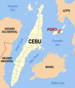
 Map of Cebu with Poro highlighted | |
Location within the Philippines | |
| Coordinates: 10°37′44″N 124°24′25″E / 10.629°N 124.407°E | |
| Country | Philippines |
| Region | Central Visayas |
| Province | Cebu |
| District | 5th district |
| Founded | 17 December 1701 |
| Barangays | 17 (see Barangays) |
| Government | |
| • Type | Sangguniang Bayan |
| • Mayor | Edgar G. Rama |
| • Vice Mayor | Dina Z. Rama |
| • Representative | Vincent Franco D. Frasco |
| • Municipal Council | Members |
| • Electorate | 17,158 voters (2022) |
| Area | |
• Total | 63.59 km2 (24.55 sq mi) |
| Elevation | 48 m (157 ft) |
| Highest elevation | 377 m (1,237 ft) |
| Lowest elevation | 0 m (0 ft) |
| Population (2020 census)[3] | |
• Total | 26,232 |
| • Density | 410/km2 (1,100/sq mi) |
| • Households | 6,900 |
| Economy | |
| • Income class | 4th municipal income class |
| • Poverty incidence | 44.60 |
| • Revenue | ₱ 110.7 million (2020) |
| • Assets | ₱ 417.2 million (2020) |
| • Expenditure | ₱ 103.7 million (2020) |
| • Liabilities | ₱ 171.2 million (2020) |
| Service provider | |
| • Electricity | Camotes Electric Cooperative (CELCO) |
| Time zone | UTC+8 (PST) |
| ZIP code | 6049 |
| PSGC | |
| IDD : area code | +63 (0)32 |
| Native languages | Forohanon Cebuano |
Poro, officially the Municipality of Poro (Cebuano: Lungsod sa Poro; Tagalog: Bayan ng Poro), is a 4th class municipality in the province of Cebu, Philippines. According to the 2020 census, it has a population of 26,232 people.[3]
Poro, along with the municipality of Tudela, is located on Poro Island of the Camotes Islands.
Poro is bordered to the north by the Province of Leyte in the Camotes Sea, to the west is by the island of Pacijan Island With the town of San Francisco, to the east is the town of Tudela and to the south is the Camotes Sea
The patronal feast of Poro is celebrated on the third Friday of January, in honour of the Santo Niño de Cebu.
- ^ Municipality of Poro | (DILG)
- ^ "2015 Census of Population, Report No. 3 – Population, Land Area, and Population Density" (PDF). Philippine Statistics Authority. Quezon City, Philippines. August 2016. ISSN 0117-1453. Archived (PDF) from the original on May 25, 2021. Retrieved July 16, 2021.
- ^ a b Census of Population (2020). "Region VII (Central Visayas)". Total Population by Province, City, Municipality and Barangay. Philippine Statistics Authority. Retrieved 8 July 2021.
- ^ "PSA Releases the 2021 City and Municipal Level Poverty Estimates". Philippine Statistics Authority. 2 April 2024. Retrieved 28 April 2024.


