| Porongurup National Park Western Australia | |
|---|---|
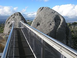
 The Castle Rock skywalk | |
 | |
| Nearest town or city | Mount Barker, Western Australia |
| Coordinates | 34°40′46″S 117°52′23″E / 34.67944°S 117.87306°E |
| Established | 1971 |
| Area | 26.21 km2 (10.1 sq mi)[1] |
| Managing authorities | Department of Parks and Wildlife |
| Website | Porongurup National Park |
| See also | List of protected areas of Western Australia |
| Designations | |
|---|---|
| Official name | Porongurup National Park |
| Type | Natural |
| Designated | 21 March 1978 |
| Reference no. | 9385 |
| Place File Number | 5/01/081/0003 |
| Official name | Porongurup National Park |
| Type | Natural |
| Designated | 4 August 2009 |
| Reference no. | 105982 |
| Place File Number | 5/01/081/0035 |
Porongurup National Park is a national park in the Great Southern region of Western Australia.[2] It covers 26.21 square kilometres (10.12 sq mi), and is 360 kilometres (220 mi) southeast of Perth and 40 kilometres (25 mi) north of Albany.
The park contains the Porongurup Range, which is the relic core of an ancient mountain range formed in the Precambrian over 1200 million years ago.[3] The Porongurup Range forms part of the Southwest Biodiversity Hotspot,[4] which is one of 34 regions in the world noted for a rich diversity of flora and fauna species.[5] The range contains many peaks and hiking trails, with the highest point being Devils Slide at 670 metres (2,200 ft),[6][2]: 1 followed by Nancy's Peak at 644 metres. Castle Rock (558 metres) is capped with The Granite Skywalk,[7] a steel viewing platform which provides panoramic views of the surrounding karri forest.
- ^ "Department of Environment and Conservation 2009–2010 Annual Report". Annual Report. Department of Environment and Conservation: 48. 2010. ISSN 1835-114X. Archived from the original on 11 January 2011.
- ^ a b Cite error: The named reference
hegi99was invoked but never defined (see the help page). - ^ Lane, Peter (2017). Geology of Western Australia's National Parks (4th ed.). Margaret River, WA: Peter Lane. p. 53. ISBN 9780646439952.
- ^ Hales, Lydia (19 February 2014). "Biodiversity hotspot in WA explained". Australian Geographic. Retrieved 1 August 2022.
- ^ Hopper, Stephen D; Gioia, Paul (2004). "The Southwest Australian Floristic Region: Evolution and Conservation of a Global Hot Spot of Biodiversity". Annual Review of Ecology, Evolution, and Systematics. 35: 623–650. doi:10.1146/annurev.ecolsys.35.112202.130201. JSTOR 30034129.
- ^ Cite error: The named reference
pws18was invoked but never defined (see the help page). - ^ "Granite Skywalk". Exploreparks.dbca.wa.gov.au. Retrieved 1 August 2022.
