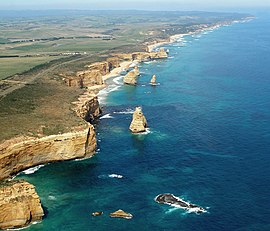
| Port Campbell National Park Victoria | |
|---|---|
 Port Campbell National Park coastline | |
 | |
| Nearest town or city | Port Campbell |
| Coordinates | 38°39′02″S 143°03′46″E / 38.65056°S 143.06278°E |
| Established | 5 May 1964[1] |
| Area | 17.5 km2 (6.8 sq mi)[1] |
| Visitation | circa 2,000,000 (in 1998)[1] |
| Managing authorities | Parks Victoria |
| Website | Port Campbell National Park |
| See also | Protected areas of Victoria |
The Port Campbell National Park is a national park in the south-western district of Victoria, Australia. The 1,750-hectare (4,300-acre) national park is situated approximately 190 kilometres (120 mi) south-west of Melbourne and approximately 10 kilometres (6.2 mi) east of Warrnambool. The park is located adjacent to the Great Otway National Park and the Bay of Islands Coastal Park.
- ^ a b c "Port Campbell National Park and Bay of Islands Coastal Park management plan" (PDF). Parks Victoria (PDF). Government of Victoria. September 1998. pp. 3–5, 26. ISBN 0-7311-3133-9. Archived from the original (PDF) on 4 March 2016. Retrieved 25 August 2014.
