| Port Hacking Sydney, New South Wales | |||||||||||||||
|---|---|---|---|---|---|---|---|---|---|---|---|---|---|---|---|
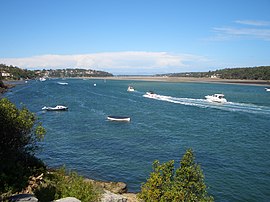
 Port Hacking estuary, view towards the heads | |||||||||||||||
 | |||||||||||||||
| Coordinates | 34°4′8″S 151°7′22″E / 34.06889°S 151.12278°E | ||||||||||||||
| Population | 1,093 (2016 census)[1] | ||||||||||||||
| Postcode(s) | 2229 | ||||||||||||||
| Elevation | 47 m (154 ft) | ||||||||||||||
| Location | 26 km (16 mi) south of Sydney CBD | ||||||||||||||
| LGA(s) | Sutherland Shire | ||||||||||||||
| State electorate(s) | Cronulla | ||||||||||||||
| Federal division(s) | Cook | ||||||||||||||
| |||||||||||||||
Port Hacking is a small bayside suburb located on the north shore of the Port Hacking estuary in southern Sydney, in the state of New South Wales, Australia. The suburb is situated 26.7 kilometres south of the Sydney central business district in the local government area of the Sutherland Shire.
- ^ Australian Bureau of Statistics (27 June 2017). "Port Hacking (State Suburb)". 2016 Census QuickStats. Retrieved 6 November 2017.
