| Port Hacking Estuary | |
|---|---|
| Deeban (Dharawal)[1] | |
 Looking inland over Port Hacking estuary towards the west from the Tasman Sea. | |
Location of Port Hacking in Sydney, New South Wales | |
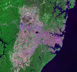
 Port Hacking, the southernmost inlet shown on a 2005 NASA image of the urban sprawl of Greater Sydney | |
| Location | Southern Sydney, New South Wales |
| Coordinates | 34°03′55″S 151°08′05″E / 34.06528°S 151.13472°E[2] |
| Type | An open youthful tide dominated, drowned valley estuary[3] |
| Etymology | in honour of Henry Hacking, a pilot at Port Jackson[1] |
| Primary inflows | Hacking River |
| Primary outflows | Tasman Sea |
| Catchment area | 165.3 km2 (63.8 sq mi) |
| Basin countries | Australia |
| Managing agency | Sutherland Shire Council, |
| Surface area | 11.7 km2 (4.5 sq mi) |
| Average depth | 9.1 m (30 ft) |
| Water volume | 105,261.5 km3 (8.53369×10¹⁰ acre⋅ft) |
| Frozen | never |
| Settlements | Bundeena, Cronulla, Woolooware, Burraneer, Caringbah South, Dolans Bay, Port Hacking, Lilli Pilli, Yowie Bay, Miranda, Gymea Bay, Grays Point |
| Website | NSW Environment and Heritage webpage |
Port Hacking Estuary (Aboriginal Tharawal language: Deeban[1]), an open youthful tide dominated, drowned valley estuary,[3] is located in southern Sydney, New South Wales, Australia[4] approximately 30 kilometres (19 mi) south of Sydney central business district. Port Hacking has its source in the upper reaches of the Hacking River south of Helensburgh, and several smaller creeks, including South West Arm, Bundeena Creek and The Basin and flows generally to the east before reaching its mouth, the Tasman Sea, south of Cronulla and north–east of Bundeena. Its tidal effect is terminated at the weir at Audley, in the Royal National Park. The lower estuary features a substantial marine delta, which over time has prograded upstream. There is also a substantial fluvial (riverine delta) of the Hacking River at Grays Point. The two deltas are separated by a deep basin.
The total catchment area of Port Hacking is approximately 165 square kilometres (64 sq mi) and the area surrounding the estuary is generally managed by Sutherland Shire Council. While the area to the north of Port Hacking is urbanised, the area to the south is relatively pristine and forms the northern boundary of the Royal National Park.
The land adjacent to Port Hacking was occupied for many thousands of years by the Tharawal and Eora, both Aboriginal peoples, and their associated clans. They used the bay as an important source of food and a place for trade.
- ^ a b c "Port Hacking (Bay)". Geographical Names Register (GNR) of NSW. Geographical Names Board of New South Wales. Retrieved 8 January 2013.
- ^ "Port Hacking (NSW)". Gazetteer of Australia online. Geoscience Australia, Australian Government.
- ^ a b Roy, P. S; Williams, R. J; Jones, A. R; Yassini, I; et al. (2001). "Structure and Function of South-east Australian Estuaries". Estuarine, Coastal and Shelf Science. 53: 351–384. doi:10.1006/ecss.2001.0796.
- ^ "Port Hacking". Geoscience Australia. Archived from the original on 29 May 2007. Retrieved 7 July 2006.
