Port Hueneme, California
Hueneme | |
|---|---|
| City of Port Hueneme | |
 | |
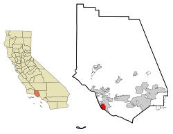
 Location in Ventura County | |
| Coordinates: 34°9′37″N 119°11′40″W / 34.16028°N 119.19444°W | |
| Country | United States |
| State | California |
| County | Ventura |
| Wharf constructed | 1871[1] |
| Street grid established | October 1, 1888[2] |
| Incorporated | March 24, 1948[3] |
| Government | |
| • Type | Council-mayor |
| • Mayor | Misty Perez [4] |
| • State senator | Monique Limón (D)[5] |
| • Assemblymember | Laura Friedman (D)[5] |
| • U. S. rep. | Julia Brownley (D)[6] |
| Area | |
• Total | 4.67 sq mi (12.09 km2) |
| • Land | 4.42 sq mi (11.44 km2) |
| • Water | 0.25 sq mi (0.65 km2) 4.70% |
| Elevation | 13 ft (4 m) |
| Population | |
• Total | 21,954 |
| • Density | 4,700/sq mi (1,800/km2) |
| Time zone | UTC-8 (Pacific) |
| • Summer (DST) | UTC-7 (PDT) |
| ZIP codes | 93041–93044 |
| Area code | 805 |
| FIPS code | 06-58296 |
| GNIS feature ID | 1652778 |
| Website | www |
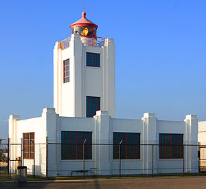
Port Hueneme (/waɪˈniːmi/ wy-NEEM-ee; Chumash: Wene Me) is a small beach city in Ventura County, California, surrounded by the city of Oxnard and the Santa Barbara Channel.[10] Both the Port of Hueneme and Naval Base Ventura County lie within the city limits.
Port Hueneme has a south-facing sand beach, known for its surfing. The beach has a wooden fishing pier[11] and is about a mile long between Ormond Beach[12] downcoast and Point Hueneme Light at the harbor entrance shared by the naval base and the port. The Waterfront Promenade, also known as the Lighthouse Promenade, provides a paved public access along the shoreline with two historic sites at viewpoints: the 1872 Wharf and the Oxnard Packing House.[13][14]
- ^ Cite error: The named reference
nrhpdocwas invoked but never defined (see the help page). - ^ Cite error: The named reference
mapwas invoked but never defined (see the help page). - ^ "California Cities by Incorporation Date". California Association of Local Agency Formation Commissions. Archived from the original (Word) on February 21, 2013. Retrieved August 25, 2014.
- ^ "City Council". Port Hueneme, CA. Retrieved September 16, 2015.
- ^ a b "Statewide Database". Regents of the University of California. Archived from the original on February 1, 2015. Retrieved April 17, 2015.
- ^ "California's 26th Congressional District - Representatives & District Map". Civic Impulse, LLC. Retrieved October 5, 2014.
- ^ "2019 U.S. Gazetteer Files". United States Census Bureau. Retrieved July 1, 2020.
- ^ "Port Hueneme". Geographic Names Information System. United States Geological Survey, United States Department of the Interior. Retrieved April 17, 2015.
- ^ "US Census Bureau". www.census.gov. Retrieved September 8, 2024.
- ^ Greenland, Powell. "Port Hueneme." (1994, Ventura County Maritime Museum). ISBN 0870951114.
- ^ Wenner, Gretchen (April 15, 2019). "Will Port Hueneme Pier be renamed Sharkey Pier? City Council to decide". Ventura County Star. Retrieved April 15, 2019.
- ^ U.S. Geological Survey Geographic Names Information System: Ormond Beach
- ^ Klampe, Michelle L. (March 21, 2008) "Waterfront Promenade officially opens today" Ventura County Star
- ^ Cultural Heritage Board. "Ventura County Landmark Map" Archived October 16, 2015, at the Wayback Machine County of Ventura Planning Division Accessed April 5, 2014


