Port Norris, New Jersey | |
|---|---|
 Along Main Street near Ogden Avenue | |
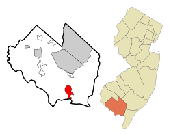
 Map Location of Port Norris in Cumberland County highlighted in red (left). Inset map: Location of Cumberland County in New Jersey highlighted in orange (right). | |
| Coordinates: 39°15′02″N 75°02′33″W / 39.250469°N 75.042457°W | |
| Country | |
| State | |
| County | Cumberland |
| Township | Commercial |
| Area | |
| • Total | 6.92 sq mi (17.93 km2) |
| • Land | 6.38 sq mi (16.52 km2) |
| • Water | 0.55 sq mi (1.42 km2) 7.23% |
| Elevation | 10 ft (3 m) |
| Population | |
| • Total | 1,111 |
| • Density | 174.19/sq mi (67.26/km2) |
| Time zone | UTC−05:00 (Eastern (EST)) |
| • Summer (DST) | UTC−04:00 (Eastern (EDT)) |
| ZIP Code | 08349[4] |
| Area code | 856 |
| FIPS code | 34-60510[5][6][7] |
| GNIS feature ID | 02389697[5][8] |
Port Norris is an unincorporated community and census-designated place (CDP)[9] located within Commercial Township, in Cumberland County, in the U.S. state of New Jersey.[10][11] It is part of the Vineland-Millville- Bridgeton Primary Metropolitan Statistical Area for statistical purposes. As of the 2000 United States Census, the CDP's population was 1,377.[12] Legislation was passed in 1911 allowing voters to choose to incorporate Port Norris as a borough, independent from Commercial Township, but it was defeated in a referendum.[13]
- ^ "ArcGIS REST Services Directory". United States Census Bureau. Retrieved October 11, 2022.
- ^ U.S. Geological Survey Geographic Names Information System: Port Norris Census Designated Place, Geographic Names Information System. Accessed November 2, 2012.
- ^ Census Data Explorer: Port Norris CDP, New Jersey, United States Census Bureau. Accessed June 15, 2023.
- ^ Look Up a ZIP Code for Port Norris, NJ, United States Postal Service. Accessed November 2, 2012.
- ^ a b Gazetteer of New Jersey Places, United States Census Bureau. Accessed July 21, 2016.
- ^ U.S. Census website, United States Census Bureau. Accessed September 4, 2014.
- ^ Geographic Codes Lookup for New Jersey, Missouri Census Data Center. Accessed June 9, 2023.
- ^ US Board on Geographic Names, United States Geological Survey. Accessed September 4, 2014.
- ^ State of New Jersey Census Designated Places - BVP20 - Data as of January 1, 2020, United States Census Bureau. Accessed December 1, 2022.
- ^ New Jersey: 2010 - Population and Housing Unit Counts - 2010 Census of Population and Housing (CPH-2-32), United States Census Bureau, August 2012. Accessed November 2, 2012.
- ^ Locality Search, State of New Jersey. Accessed April 19, 2015.
- ^ DP-1 - Profile of General Population and Housing Characteristics: 2010 Demographic Profile Data for Port Norris CDP, New Jersey, United States Census Bureau. Accessed November 2, 2012.
- ^ Snyder, John P. The Story of New Jersey's Civil Boundaries: 1606-1968, Bureau of Geology and Topography; Trenton, New Jersey; 1969. p. 259. Accessed November 17, 2015.