Porter Heights, Texas | |
|---|---|
 Porter Heights with North Houston Airport, looking northeastwards | |
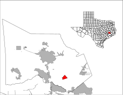
 Location of Porter Heights, Texas | |
| Coordinates: 30°9′1″N 95°19′3″W / 30.15028°N 95.31750°W | |
| Country | United States |
| State | Texas |
| County | Montgomery |
| Area | |
| • Total | 3.2 sq mi (8.2 km2) |
| • Land | 3.2 sq mi (8.2 km2) |
| • Water | 0.0 sq mi (0.0 km2) |
| Elevation | 125 ft (38 m) |
| Population | |
| • Total | 1,903 |
| • Density | 516.6/sq mi (201.6/km2) |
| Time zone | UTC-6 (Central (CST)) |
| • Summer (DST) | UTC-5 (CDT) |
| FIPS code | 48-58850[2] |
| GNIS feature ID | 1867563[3] |
Porter Heights is a census-designated place (CDP) in Montgomery County, Texas, United States. The population was 1,903 at the 2020 census.
- ^ Factfinder: Porter Heights. Archived 2020-02-13 at archive.today United States Census Bureau. Accessed on July 11, 2017
- ^ "U.S. Census website". United States Census Bureau. Retrieved January 31, 2008.
- ^ "US Board on Geographic Names". United States Geological Survey. October 25, 2007. Retrieved January 31, 2008.