| Portgate | |
|---|---|
| Northumberland, England, UK | |
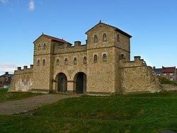
 Although the structure of the Portgate is unknown, it is likely to have resembled this reconstruction gateway at Arbeia | |
Location in Northumberland | |
| Coordinates | 55°00′46″N 2°01′18″W / 55.012663°N 2.021612°W |
| Grid reference | NY98736869 |
The Portgate was a fortified gateway, constructed as part of Hadrian's Wall where it crossed the Roman road now known as Dere Street, which preceded Hadrian's Wall by around 50 years. It was built to control traffic along Dere Street as it passed north through Hadrian's Wall. The gate's remains exist beneath the old B6318 Military Road to the south-west of the Stagshaw Roundabout (the B6318 was diverted slightly for the construction of the Stagshaw Roundabout, leaving two short sections of the existing road unlinked – the remains of the Portgate are buried beneath the western section).[1]

- ^ "Portgate". Pastscape. English Heritage. Archived from the original on 10 March 2012. Retrieved 26 August 2010.
