| Portswood | |
|---|---|
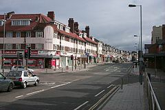
 Portswood's shopping area (Portswood Road) | |
Location within Southampton | |
| Area | 2.79 km2 (1.08 sq mi) |
| Population | 14,831 [1] |
| • Density | 5,316/km2 (13,770/sq mi) |
| OS grid reference | SU434150 |
| Unitary authority | |
| Ceremonial county | |
| Region | |
| Country | England |
| Sovereign state | United Kingdom |
| Post town | SOUTHAMPTON |
| Postcode district | SO17 |
| Dialling code | 023 |
| Police | Hampshire and Isle of Wight |
| Fire | Hampshire and Isle of Wight |
| Ambulance | South Central |
| UK Parliament | |
Portswood is a suburb and Electoral Ward of Southampton, England. The suburb lies to the north-north-east of the city centre and is bounded by (clockwise from west) Freemantle, Highfield, Swaythling, St. Denys and Bevois Valley.
Portswood Ward comprises Portswood, Highfield and St. Denys, and had a population of 14,831 at the 2011 Census.[1] It is a largely residential area adjacent to the main campus of the University of Southampton, and as such more than a quarter of residents are students.[2]
- ^ a b "UK Census data:Portswood 2011".
- ^ "Portswood (Ward) — National Statistics Socio-economic Classification (UV31)". Office for National Statistics. 2001. Retrieved 27 June 2008.
