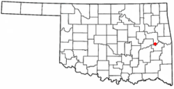
Porum, Oklahoma | |
|---|---|
Town | |
 Location of Porum, Oklahoma | |
| Coordinates: 35°21′26″N 95°15′49″W / 35.35722°N 95.26361°W | |
| Country | United States |
| State | Oklahoma |
| County | Muskogee |
| Area | |
| • Total | 0.92 sq mi (2.37 km2) |
| • Land | 0.89 sq mi (2.31 km2) |
| • Water | 0.02 sq mi (0.06 km2) |
| Elevation | 584 ft (178 m) |
| Population (2020) | |
| • Total | 602 |
| • Density | 674.89/sq mi (260.45/km2) |
| Time zone | UTC-6 (Central (CST)) |
| • Summer (DST) | UTC-5 (CDT) |
| ZIP code | 74455 |
| Area code(s) | 539/918 |
| FIPS code | 40-60250[3] |
| GNIS feature ID | 2412500[2] |
Porum is a town in Muskogee County, Oklahoma, United States. It was named for John Porum Davis, a rancher, Civil War veteran, and Cherokee Nation councilman from the Canadian District in Indian Territory. The community was first known as Porum Gap, which united with another village named Starvilla in 1905. The product of this union became the present town of Porum. The population was 727 at the 2010 census, an increase of 0.3 percent from the figure of 725 recorded in 2000.[4]
- ^ "ArcGIS REST Services Directory". United States Census Bureau. Retrieved September 20, 2022.
- ^ a b U.S. Geological Survey Geographic Names Information System: Porum, Oklahoma
- ^ "U.S. Census website". United States Census Bureau. Retrieved January 31, 2008.
- ^ Ellen Collins Johnson, "Porum," Encyclopedia of Oklahoma History and Culture. Accessed May 2, 2015.