Postville, Iowa | |
|---|---|
 | |
| Motto: | |
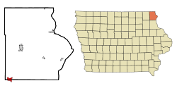
 Location of Postville, Iowa | |
| Coordinates: 43°5′6″N 91°34′10″W / 43.08500°N 91.56944°W | |
| Country | United States |
| State | Iowa |
| Counties | Allamakee, Clayton |
| Township | Post |
| Settled | June 1843 |
| Incorporated | March 11, 1873 |
| Area | |
| • Total | 2.08 sq mi (5.38 km2) |
| • Land | 2.08 sq mi (5.38 km2) |
| • Water | 0.00 sq mi (0.00 km2) |
| Elevation | 1,181 ft (360 m) |
| Population (2020) | |
| • Total | 2,503 |
| • Density | 1,205.10/sq mi (465.29/km2) |
| Time zone | UTC-6 (Central (CST)) |
| • Summer (DST) | UTC-5 (CDT) |
| ZIP code | 52162 |
| Area code | 563 |
| FIPS code | 19-64290 |
| GNIS feature ID | 0460373 |
| Website | www |
Postville is a village in Allamakee and Clayton counties in the U.S. state of Iowa. It lies near the junction of four counties and at the intersection of U.S. Routes 18 and 52 and Iowa Highway 51, with airport facilities in the neighboring communities of Waukon, Decorah, Monona and Prairie du Chien. The population was 2,503 at the time of the 2020 census, up from 2,273 in 2000.[4] The village is in Allamakee County's southwestern corner and Clayton County's northwestern corner in a quad county, or four-corner region, where four counties intersect. Winneshiek County is just to the west and Fayette County is just to the southwest of Postville.
- ^ "City of Postville, Iowa - Hometown to the World". Cityofpostville.com. Retrieved December 1, 2015.
- ^ Jones, Maggie (July 11, 2012). "Postville, Iowa, Is Up for Grabs". Nytimes.com. Retrieved February 8, 2022.
- ^ "2020 U.S. Gazetteer Files". United States Census Bureau. Retrieved March 16, 2022.
- ^ "2020 Census State Redistricting Data". census.gov. United states Census Bureau. Retrieved August 12, 2021.