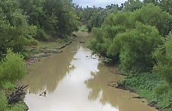
| Poteau River | |
|---|---|
 The Poteau River near Panama, Oklahoma | |
 | |
| Location | |
| Country | United States |
| States | Arkansas, Oklahoma |
| Physical characteristics | |
| Source | |
| • location | Waldron, Arkansas |
| Mouth | |
• location | Fort Smith, Arkansas[1] |
| Length | 141 mi (227 km) |
| Discharge | |
| • location | Panama, Oklahoma |
| • average | 2,253 cu ft/s (63.8 m3/s)[2] |

The Poteau River is a river located in the U.S. states of Arkansas and Oklahoma extending 141 miles (227 kilometers).[3] It is the only river in Oklahoma that flows north[4] and is the seventh-largest river in the state. The Poteau River is a tributary of the Arkansas River, which is a tributary of the Mississippi River. Prior to Oklahoma's statehood, during the Indian Territory period (1838-1906), the stream served as the boundary between Skullyville County and Sugar Loaf County, two of the counties making up the Moshulatubbee District of the Choctaw Nation.
The Poteau River also serves as the border between the states of Arkansas and Oklahoma for one mile to the south of Fort Smith. This border gives an additional 57 acres of land to Arkansas that would have instead been an exclave of the Choctaw Nation before 1905 when it was handed over to Arkansas.
- ^ "The National Map".
- ^ "USGS Surface Water data for Oklahoma: USGS Surface-Water Annual Statistics".
- ^ U.S. Geological Survey. National Hydrography Dataset high-resolution flowline data. The National Map, accessed June 3, 2011
- ^ Corps Lakes Gateway: Oklahoma - Wister Lake Archived 2007-06-26 at the Wayback Machine