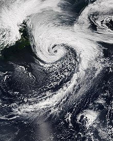
|name=. Remove this parameter; the article title is used as the name by default. Potential Tropical Cyclone Ten at peak intensity on August 31, as a strong extratropical cyclone | |
| Meteorological history | |
|---|---|
| Formed | August 27, 2017 |
| Extratropical | August 29, 2017 |
| Dissipated | September 3, 2017 |
| Potential tropical cyclone | |
| 1-minute sustained (SSHWS/NWS) | |
| Highest winds | 45 mph (75 km/h) |
| Lowest pressure | 1004 mbar (hPa); 29.65 inHg (971 mbar (27.92 inHg) while extratropical) |
| Overall effects | |
| Fatalities | 2 total |
| Damage | >$1.92 million (2017 USD) |
| Areas affected | Leeward Islands, Puerto Rico, Bahamas, Southeastern United States, Mid-Atlantic states, New England, Atlantic Canada |
Part of the 2017 Atlantic hurricane season (Unofficially) | |
Potential Tropical Cyclone Ten was a damaging storm that was the tenth tropical disturbance designated by the National Hurricane Center (NHC) during the 2017 Atlantic hurricane season. The disturbance was deemed to have a very high chance of becoming a tropical cyclone while posing a threat to populated areas and was designated a "Potential Tropical Cyclone". The storm caused flooding and brought tropical storm-force winds to parts of the Southeastern United States and the Mid-Atlantic states, particularly Florida and the Carolinas, before going on to affect parts of Atlantic Canada. Potential Tropical Cyclone Ten was the tenth storm that had advisories issued on it by the NHC in 2017, and the only such system that failed to fully develop into a tropical cyclone during that Atlantic hurricane season. Potential Tropical Cyclone Ten originated from a tropical wave that moved off the coast of West Africa on August 13. The disturbance slowly tracked its way westward across the Atlantic Ocean, before reaching Florida in late August. The disturbance came close to developing into a tropical storm while it was situated off the coast of the Carolinas; however, strong wind shear and outflow from Hurricane Harvey prevented the storm from organizing into a tropical cyclone. The system transitioned into an extratropical cyclone instead, and became a strong hurricane-force low to the south of Newfoundland, before being absorbed by another extratropical system near Iceland on September 3.
The storm caused flooding across Florida, especially around Fort Myers and other areas in southwestern Florida, forcing the evacuation of more than 200 people. The disturbance dropped a maximum total of rainfall in excess of 30 inches (76 cm) of rain in Ten Mile Canal and Six Mile Cypress Slough Preserve, in southwestern Florida, in addition to 18 inches (46 cm) of rain in the western parts of Fort Myers.[1] The flooding was the worst seen in western Florida in at least 20 years.[2] Overall, the storm killed two people and caused more than $1.923 million (2017 USD) in damages.[3] Less than two weeks after the storm, Hurricane Irma made landfall in southwestern Florida, which further compounded the damage in the region.[4][5]
- ^ Cite error: The named reference
flooding subsideswas invoked but never defined (see the help page). - ^ Cite error: The named reference
plagueswas invoked but never defined (see the help page). - ^ Cite error: The named reference
NCDCwas invoked but never defined (see the help page). - ^ Cite error: The named reference
growing impatientwas invoked but never defined (see the help page). - ^ Cite error: The named reference
Hurricane Irmawas invoked but never defined (see the help page).