| Potlatch River | |
|---|---|
 The Potlatch near Kendrick | |
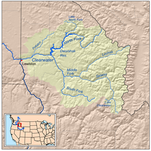
 Map of the Clearwater River watershed showing the Potlatch River in the upper left | |
| Location | |
| Country | United States |
| State | Idaho |
| Region | Latah County, Clearwater County, Nez Perce County |
| Physical characteristics | |
| Source | Hoodoo Mountains Confluence of East and West Forks |
| • location | Rocky Mountains, Latah County |
| • coordinates | 46°55′43″N 116°20′55″W / 46.92861°N 116.34861°W |
| • elevation | 2,674 ft (815 m) |
| Mouth | Clearwater River |
• location | Between Myrtle and Spalding, Nez Perce County |
• coordinates | 46°28′31″N 116°46′02″W / 46.47528°N 116.76722°W |
• elevation | 801 ft (244 m) |
| Length | 56 mi (90 km), Northeast-southwest |
| Basin size | 594 sq mi (1,540 km2)[1] |
| Discharge | |
| • average | 379.8 cu ft/s (10.75 m3/s) |
| • minimum | 75 cu ft/s (2.1 m3/s) |
| • maximum | 8,150 cu ft/s (231 m3/s) |
| Basin features | |
| River system | Clearwater River |
| Tributaries | |
| • left | Cedar Creek (Idaho) |
| • right | Big Bear Creek |
The Potlatch River is in the state of Idaho in the United States.[2] About 56 miles (90 km) long, it is the lowermost major tributary to the Clearwater River, a tributary of the Snake River that is in turn a tributary of the Columbia River.[3] Once surrounded by arid grasslands of the Columbia Plateau adjacent to the western foothills of the Rocky Mountains, the Potlatch today is used mainly for agriculture and irrigation purposes.
Its name derives from potlatch, a type of ceremony held by the indigenous people of the Pacific Northwest; one such tribe lived along the river for hundreds of years before the arrival of settlers. Pioneers settled the watershed and established farms and ranches in the late 19th century. After that, logging eliminated most of the forests within the watershed and the ecology of the river is still in the process of recovery. Fishing, hiking and camping are popular recreational activities on the river; 14 percent the watershed lies on public lands. Before logging and agriculture, many varieties of riparian and forest plants once populated the catchment, and several species of fish still swim the river and its tributaries.
- ^ "Surface Water: Potlatch River Subbasin Assessment and Total Maximum Daily Loads". Water. Idaho Department of Environmental Quality. Archived from the original on 2009-09-30. Retrieved 2010-04-09.
- ^ "Potlatch River". Geographic Names Information System. United States Geological Survey, United States Department of the Interior. 1979-06-21. Retrieved 2010-01-23.
- ^ "Potlatch River Watershed Management Plan" (PDF). Resource Planning Unlimited. Latah Soil and Water Conservation District. October 2007. Archived from the original (PDF) on 2011-07-13. Retrieved 2010-01-23.