 | |
 | |
| Location | On Poverty Island in NW Lake Michigan, 5.8 miles (9.3 km) south of the Garden Peninsula |
|---|---|
| Coordinates | 45°31′38″N 86°39′49″W / 45.52722°N 86.66361°W |
| Tower | |
| Constructed | 1875 |
| Foundation | dressed stone |
| Construction | brick |
| Automated | 1957[1] |
| Height | 65 feet (20 m)[1] |
| Shape | conical[2] |
| Markings | white[2] |
| Heritage | National Register of Historic Places listed place |
| Light | |
| First lit | 1875 |
| Deactivated | 1976 |
| Focal height | 78 feet (24 m)[1] |
| Lens | fourth order Fresnel lens[1] |
| Range | 14 nautical miles; 26 kilometres (16 mi)[1] |
Poverty Island Light Station | |
| Area | 171.2 acres (69.3 ha) |
| Built by | U.S. Lighthouse Board; U.S. Lighthouse Service |
| MPS | Light Stations of the United States MPS |
| NRHP reference No. | 05000984[3] |
| Added to NRHP | September 6, 2005 |
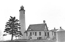
The Poverty Island Light is a light house located on Poverty Island in northwestern Lake Michigan, 5.8 miles (9.3 km) south of Garden Peninsula. It was listed on the National Register of Historic Places in 2005 as the Poverty Island Light Station.[3]
- ^ a b c d e Cite error: The named reference
stlwas invoked but never defined (see the help page). - ^ a b "Poverty Island Light". Narional Park Service Inventory of Historic Light Stations: Michigan Lighthouses. Retrieved April 9, 2012.
- ^ a b "National Register Information System". National Register of Historic Places. National Park Service. July 9, 2010.