Powell River | |
|---|---|
| City of Powell River | |
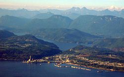
 Powell River Mill and townsite area of Powell River. The river runs from Powell Lake (background) to the mill. | |
| Coordinates: 49°50′08″N 124°31′28″W / 49.83556°N 124.52444°W[1] | |
| Country | Canada |
| Province | British Columbia |
| Region | Sunshine Coast |
| Regional District | qathet Regional District |
| Established | 1912 |
| Incorporated | 1955 |
| Reincorporated as a City | 2005 |
| Government | |
| • Mayor | Ron Woznow |
| • City Council | List of Councillors |
| Area | |
• City | 28.91 km2 (11.16 sq mi) |
| • Metro | 800.72 km2 (309.16 sq mi) |
| Elevation | 50 m (164 ft) |
| Population (2016)[3] | |
• City | 13,157 |
| • Density | 444.1/km2 (1,150/sq mi) |
| • Metro | 16,783 |
| • Metro density | 21.0/km2 (54/sq mi) |
| District pop = 20,070 | |
| Time zone | UTC−08:00 (PST) |
| • Summer (DST) | UTC−07:00 (PDT) |
| Forward sortation area | |
| Area code(s) | 604, 778, 236, 672 |
| Website | powellriver |
Powell River is a city on the northern Sunshine Coast of southwestern British Columbia, Canada.[4] Most of its population lives near the eastern shores of Malaspina Strait, which is part of the larger Georgia Strait between Vancouver Island and the Mainland. With two intervening long, steep-sided fjords inhibiting the construction of a contiguous road connection with Vancouver to the south, geographical surroundings explain Powell River's remoteness as a community, despite relative proximity to Vancouver and other populous areas of the BC Coast. The city is the location of the head office of the qathet Regional District.
- ^ "Powell River". Geographical Names Data Base. Natural Resources Canada.
- ^ "Powell River electors return George Doubt to city council". The Peak.
- ^ "Population and Dwelling Counts". Retrieved 2013-02-19.
- ^ "BC Geographical Names". apps.gov.bc.ca.
