Powers, Oregon | |
|---|---|
 Powers, Oregon skyline | |
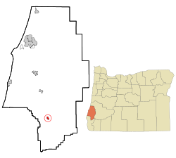
 Location in Oregon | |
| Coordinates: 42°53′0″N 124°4′23″W / 42.88333°N 124.07306°W | |
| Country | United States |
| State | Oregon |
| County | Coos |
| Incorporated | 1945 |
| Government | |
| • Mayor | Robert Kohn |
| Area | |
| • Total | 0.63 sq mi (1.64 km2) |
| • Land | 0.58 sq mi (1.51 km2) |
| • Water | 0.05 sq mi (0.13 km2) |
| Elevation | 266 ft (81 m) |
| Population | |
| • Total | 710 |
| • Density | 1,215.75/sq mi (469.69/km2) |
| Time zone | UTC-8 (Pacific) |
| • Summer (DST) | UTC-7 (Pacific) |
| ZIP code | 97466 |
| Area code | 541 |
| FIPS code | 41-59600[4] |
| GNIS feature ID | 2411482[2] |
Powers is a city in Coos County, Oregon, United States. The population was 689 at the 2010 census.[5]
- ^ "ArcGIS REST Services Directory". United States Census Bureau. Retrieved October 12, 2022.
- ^ a b U.S. Geological Survey Geographic Names Information System: Powers, Oregon
- ^ Cite error: The named reference
USCensusDecennial2020CenPopScriptOnlywas invoked but never defined (see the help page). - ^ Cite error: The named reference
wwwcensusgovwas invoked but never defined (see the help page). - ^ "2010 Census profiles: Oregon cities alphabetically M-P" (PDF). Portland State University Population Research Center. Archived from the original (PDF) on November 7, 2018. Retrieved September 25, 2011.