| Powwow River | |
|---|---|
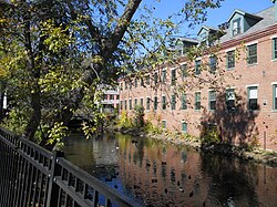
 The Powwow River in downtown Amesbury, MA | |
| Location | |
| Country | United States |
| States | New Hampshire, Massachusetts |
| Counties | Rockingham, NH, Essex, MA |
| Towns and city | Danville, NH, Kingston, NH, East Kingston, NH, South Hampton, NH, Amesbury, MA |
| Physical characteristics | |
| Source | |
| • location | Danville, NH |
| • coordinates | 42°56′0″N 71°7′52″W / 42.93333°N 71.13111°W |
| • elevation | 165 ft (50 m) |
| Mouth | Merrimack River |
• location | Amesbury, MA |
• coordinates | 42°50′26″N 70°55′28″W / 42.84056°N 70.92444°W |
• elevation | 0 ft (0 m) |
| Length | 22.8 mi (36.7 km) |
| Basin features | |
| Tributaries | |
| • left | Back River |
| • right | Colby Brook |
The Powwow River is a 22.8-mile-long (36.7 km)[1] river located in New Hampshire and Massachusetts in the United States. It is a tributary of the Merrimack River, part of the Gulf of Maine watershed.


