This article needs additional citations for verification. (March 2023) |
Pradera | |
|---|---|
Municipality and town | |
| Motto(s): Paz, Trabajo, Amor | |
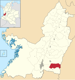
 Location of the municipality and town of Pradera in the Valle del Cauca Department of Colombia. | |
| Coordinates: 3°25′16″N 76°14′41″W / 3.42111°N 76.24472°W | |
| Country | |
| Department | Valle del Cauca Department |
| Subregion | South |
| Settled | 1862 |
| Incorporated | 1867 |
| Government | |
| • Mayor | Orlando Mina |
| Area | |
| • Municipality and town | 356.7 km2 (137.7 sq mi) |
| • Urban | 3.06 km2 (1.18 sq mi) |
| Elevation | 1,070 m (3,510 ft) |
| Population (2018 census)[1] | |
| • Municipality and town | 47,615 |
| • Density | 130/km2 (350/sq mi) |
| • Urban | 41,422 |
| • Urban density | 14,000/km2 (35,000/sq mi) |
| Demonym(s) | Praderaño, Praderaña |
| Time zone | UTC-5 (Colombia Standard Time) |
| Area code | 57 + 2 |
| Website | Official website (in Spanish) |
Pradera (Spanish pronunciation: [pɾaˈðeɾa]) is a town and municipality in the Department of Valle del Cauca, Colombia.
Pradera is one of 42 municipalities in Valle de Cauca, and is located in the south-eastern corner of the department. Its geography is characterized by large mountain ranges of the Andes and meadows, which are largely used for sugarcane cultivation.

