Prague 4
Praha 4 | |
|---|---|
Municipal District of Prague Administrative District of Prague | |
 Aerial view of Pankrác | |
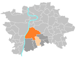
 Location of Prague 4 in Prague | |
| Coordinates: 50°3′44″N 14°26′25″E / 50.06222°N 14.44028°E | |
| Country | Czech Republic |
| Region | Prague |
| Government | |
| • Mayor | Ondřej Kubín |
| Area | |
• Total | 24.19 km2 (9.34 sq mi) |
| Population (2021) | |
• Total | 130,957 |
| • Density | 5,400/km2 (14,000/sq mi) |
| Time zone | UTC+1 (CET) |
| • Summer (DST) | UTC+2 (CEST) |
| Postal code | 140 00 |
| Website | http://www.praha4.cz |
Prague 4, formally the Prague 4 Municipal District (Městská čast Praha 4), is a second-tier municipality in Prague. The administrative district (správní obvod) of the same name consists of municipal districts Prague 4 and Kunratice.
Prague 4 is located just south of Prague 2 and is the biggest municipality in Prague. Most of this district consists of large estates of panelaks. The district is also well connected to the motorway to Brno.

