| Prahova | |
|---|---|
 The Prahova near Adâncata | |
 | |
| Location | |
| Country | Romania |
| Counties | Brașov, Prahova, Ialomița |
| Towns | Bușteni, Sinaia, Comarnic, Breaza, Câmpina |
| Physical characteristics | |
| Source | Predeal |
| • coordinates | 45°30′30″N 25°34′32″E / 45.50833°N 25.57556°E |
| • elevation | 1,037 m (3,402 ft) |
| Mouth | Ialomița |
• location | Patru Frați |
• coordinates | 44°42′55″N 26°28′14″E / 44.71528°N 26.47056°E |
• elevation | 63 m (207 ft) |
| Length | 193 km (120 mi) |
| Basin size | 3,738 km2 (1,443 sq mi) |
| Discharge | |
| • location | * |
| • average | 28.3 m3/s (1,000 cu ft/s) |
| Basin features | |
| Progression | Ialomița→ Danube→ Black Sea |
| Tributaries | |
| • left | Doftana, Teleajen, Cricovul Sărat |
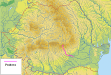
The Prahova is a river of Southern Romania, which rises from the Bucegi Mountains, in the Southern Carpathians. It is a left tributary of the Ialomița.[1][2] It flows into the Ialomița in Dridu Snagov.[3] The upper reach of the river, upstream of the confluence with the river Azuga is sometimes called the Prahovița.
It has a length of 193 km (120 mi),[2][4] of which 6 km (3.7 mi) are in Brașov County, 161 km (100 mi) are in Prahova County and the last 16 km (9.9 mi) are in Ialomița County.
The basin of the Prahova covers 3,738 km2 (1,443 sq mi),[2][4] which is about 75% of the area of Prahova County.
- ^ "Planul național de management. Sinteza planurilor de management la nivel de bazine/spații hidrografice, anexa 7.1" (PDF, 5.1 MB). Administrația Națională Apele Române. 2010. pp. 851–854.
- ^ a b c Atlasul cadastrului apelor din România. Partea 1 (in Romanian). Bucharest: Ministerul Mediului. 1992. pp. 350–356. OCLC 895459847. River code: XI.1.20
- ^ Prahova, e-calauza.ro
- ^ a b 2017 Romanian Statistical Yearbook, p. 13