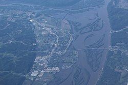
Prairie du Chien, Wisconsin | |
|---|---|
 Aerial photo of Prairie du Chien | |
 Location of Prairie du Chien in Crawford County, Wisconsin | |
| Coordinates: 43°03′06″N 91°08′29″W / 43.05167°N 91.14139°W | |
| Municipality | City |
| Area | |
• Total | 6.47 sq mi (16.76 km2) |
| • Land | 5.84 sq mi (15.13 km2) |
| • Water | 0.63 sq mi (1.63 km2) |
| Population | |
• Total | 5,506 |
| • Density | 942.3/sq mi (363.8/km2) |
| Time zone | UTC−6 (Central) |
| • Summer (DST) | UTC−5 (CDT) |
| ZIP Code | 53821 |
| Area code | 608 |
| FIPS code | 55-65050 |
| Website | www.prairieduchien.info |
Prairie du Chien (/ˌprɛəri du ˈʃiːn/ PRAIR-ee doo SHEEN) is a city in and the county seat of Crawford County, Wisconsin, United States. The population was 5,506 at the 2020 census.[2] Often called Wisconsin's second-oldest city, Prairie du Chien was established as a European settlement by French voyageurs in the late 17th century.[4] Its settlement date of June 17, 1673, makes it the fourth colonial settlement by European settlers in the Midwestern United States, after Green Bay, Wisconsin, Sault Ste. Marie, Michigan, and St. Ignace, Michigan. The city has many sites showing its rich history in the region.
Prairie du Chien is near the confluence of the Wisconsin and Mississippi rivers, a strategic point along the Fox-Wisconsin Waterway that connects the Great Lakes with the Mississippi. This location offered early French missionaries and explorers their first access and entrance to the Mississippi River. Early French visitors to the site found it occupied by a group of Fox Indians led by a chief whose name Alim meant chien in French ('dog' in English).[5][6] The French explorers named the location Prairie du Chien, French for 'dog's meadow'. Originally this name applied only to the plain upon which the settlement lay, but it was later applied to the city as well. The city of Prairie du Chien is between the town of Prairie du Chien and the town of Bridgeport.
- ^ "2019 U.S. Gazetteer Files". United States Census Bureau. Retrieved August 7, 2020.
- ^ a b Cite error: The named reference
2020-census-5565050was invoked but never defined (see the help page). - ^ "Population and Housing Unit Estimates". United States Census Bureau. May 24, 2020. Retrieved May 27, 2020.
- ^ William J. Anderson and William A. Anderson (ed.). The Wisconsin Blue Book 1929. Madison: Democrat Printing Company, 1929, p. 629.
- ^ Trewartha, Glenn T. (June 1932), "The Prairie du Chien Terrace: Geography of a Confluence Site", Annals of the Association of American Geographers, 22 (2): 119–158, doi:10.1080/00045603209357104, JSTOR 2560587
- ^ "Wisconsin Historical Markers: Marker 116: Prairie du Chien".

