This article needs additional citations for verification. (March 2015) |
Pratapgarh district | |
|---|---|
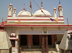
 Chauharjan Devi Temple | |
 Location of Pratapgarh district in Uttar Pradesh | |
| Coordinates (Pratapgarh, Uttar Pradesh): 25°53′49″N 81°56′42″E / 25.897°N 81.945°E | |
| Country | |
| State | Uttar Pradesh |
| Division | Prayagraj |
| Headquarters | Pratapgarh |
| Tehsils | Raniganj, Kunda, Lalganj, Patti, Sadar |
| Government | |
| • Lok Sabha constituencies | Pratapgarh (Lok Sabha constituency) |
| • Vidhan Sabha constituencies | 1. Babaganj 2. Kunda 3. Patti 4. Sadar 5. Rampur Khas 6. Raniganj 7. Vishwanathganj |
| Area | |
| • Total | 3,730 km2 (1,440 sq mi) |
| Population (2011) | |
| • Total | 3,209,141 |
| • Density | 860/km2 (2,200/sq mi) |
| • Urban | 175,242 |
| Demographics | |
| • Literacy | 73.1 % |
| Time zone | UTC+05:30 (IST) |
| Major highways | NH-96, NH-236 |
| Website | pratapgarh |
The Pratapgarh district is one of the districts of Uttar Pradesh state of India, and Pratapgarh city is the district headquarters. Pratapgarh district is a part of Prayagraj division formerly known as Allahabad. The total area of Pratapgarh district is 3730 Sq. km.[1]
- ^ "District Pratapgarh,Government of Uttar Pradesh | The City of Aonla | India". Retrieved 8 March 2021.