This article needs additional citations for verification. (January 2020) |
Prawet
ประเวศ | |
|---|---|
 | |
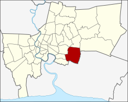
 Khet location in Bangkok | |
| Coordinates: 13°43′1″N 100°41′40″E / 13.71694°N 100.69444°E | |
| Country | Thailand |
| Province | Bangkok |
| Seat | Prawet |
| Khwaeng | 3 |
| Khet established | 9 November 1989 |
| Area | |
• Total | 52.490 km2 (20.267 sq mi) |
| Population (2017) | |
• Total | 175,656[1] |
| • Density | 3,346.47/km2 (8,667.3/sq mi) |
| Time zone | UTC+7 (ICT) |
| Postal code | 10250 (Dokmai, Mu 2-10 of Nong Bon: 10260) |
| Geocode | 1032 |
Prawet (Thai: ประเวศ, pronounced [prā.wêːt]) is one of the 50 districts of Bangkok, Thailand. It is in the southeast. Neighboring districts are (from the east clockwise) Bang Phli (Samut Prakan province), Bang Na, Phra Khanong, Suan Luang, Bang Kapi, Saphan Sung and Lat Krabang (Bangkok).
- ^ "Population and House Report for Year 2017 (see page 2 for data of this district)". Department of Provincial Administration, Ministry of Internal Affairs. Retrieved 1 April 2018. (Search page)