Prawle Point | |
|---|---|
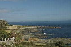
 The eastwards view from Prawle Point | |
| Coordinates: 50°12′6″N 3°43′19″W / 50.20167°N 3.72194°W |
Prawle Point (Old English: Prǣwhyll, "lookout hill") is a coastal headland in south Devon, England. It is the southernmost point of Devon. Just to the west is Elender Cove, and further west are Gammons Head Beach, also known as Maceley Cove, and Gammon Head.[1][2][3]
Access is from the village of East Prawle along a single-track road, at the end of which a National Trust car park is present. At the point itself, there are high cliffs. The National Coastwatch Institution has a station at the point.[citation needed]
The area around the point is a noted area for cirl bunting, a localised bird in Britain, while the area has also attracted many rare vagrant birds including Britain's second chestnut-sided warbler.[citation needed]
The point is included within the Prawle Point and Start Point Site of Special Scientific Interest, which stretches from here to Start Point.[citation needed]
- ^ Lewis, Simon. "Elender Cove Beach Information". Devon Beach Guide. Retrieved 28 January 2021.
- ^ "Gammons Head Beach, Devon, England". British Beaches. Retrieved 28 January 2021.
- ^ Clarkson, Steve (June 2016). "Start Point Project" (PDF). Retrieved 28 January 2021.
This Start Point project documents the research carried out by the teamon the inshore shipwrecks on the South Devon coast. It covers the area between Start Point and Prawle Point
