Prince Albert
Prins Albert | |
|---|---|
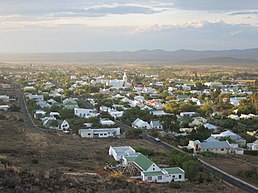
Top: View overlooking Prince Albert. Left: the Swartberg Hotel. Right: Prince Albert Dutch Reformed Church. | |
| Coordinates: 33°13′31″S 22°01′48″E / 33.22528°S 22.03000°E | |
| Country | South Africa |
| Province | Western Cape |
| District | Central Karoo |
| Municipality | Prince Albert |
| Established | 1842[1] |
| Area | |
| • Total | 37.70 km2 (14.56 sq mi) |
| Population (2011)[2] | |
| • Total | 7,054 |
| • Density | 190/km2 (480/sq mi) |
| Racial makeup (2011) | |
| • Black African | 2.2% |
| • Coloured | 85.7% |
| • Indian/Asian | 0.2% |
| • White | 11.3% |
| • Other | 0.6% |
| First languages (2011) | |
| • Afrikaans | 91.7% |
| • English | 4.7% |
| • Other | 3.6% |
| Time zone | UTC+2 (SAST) |
| Postal code (street) | 6930 |
| PO box | 6930 |
| Area code | 023 |
Prince Albert (Afrikaans: Prins Albert) is a small town in the Western Cape in South Africa. It is located on the southern edge of the Great Karoo, at the foot of the Swartberg mountains. In recent years the moniker the "Franschhoek of the Karoo" has been used to describe the town's appeal to the art community and wealthier South Africans, many of whom have become residents of the town.[3]
- ^ Robson, Linda Gillian (2011). "Annexure A" (PDF). The Royal Engineers and settlement planning in the Cape Colony 1806–1872: Approach, methodology and impact (PhD thesis). University of Pretoria. pp. xlv–lii. hdl:2263/26503.
- ^ a b c d "Main Place Prince Albert". Census 2011.
- ^ Marais, Chris (2022-06-12). "ESCAPE TO 'EMERALD CITY': Prince Albert — The creative nerve centre of the Karoo". Daily Maverick. Retrieved 2022-06-14.


