Princes Freeway | |||
|---|---|---|---|
 | |||
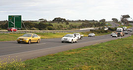
| Princes Freeway at Lara | |||
| General information | |||
| Type | Freeway | ||
| Length | 159 km (99 mi)[1][2] | ||
| Route number(s) | |||
| Former route number | |||
| Tourist routes | (Corio–Altona North) | ||
| Major junctions | |||
| |||
| Southwest end | Corio, Geelong | ||
| |||
| Northeast end | Laverton North, Melbourne | ||
| |||
| West end | Narre Warren, Melbourne | ||
| |||
| East end | Morwell, Victoria | ||
| Location(s) | |||
| Major suburbs / towns | Geelong, Little River, Werribee, Laverton, Drouin, Warragul, Moe, Morwell | ||
| Highway system | |||
| ---- | |||
Princes Freeway is a 159-kilometre (99 mi) Australian freeway, divided into two sections, both located in Victoria, Australia. The freeway links Melbourne to Geelong in the west, and to Morwell in the east. It continues beyond these extremities as the Princes Highway towards Adelaide to the west and Sydney to the northeast. The freeway bears the designation M1.
The western section linking Geelong and Melbourne is an important commuter, freight and tourism route between the two cities; the eastern section links Melbourne with the Latrobe Valley and major business suburbs, namely Dandenong and Berwick. The entire freeway is one of the busiest sections of rural highway in Victoria, used by large numbers of freight and commercial vehicles and provides access to tourist attractions in central and east Gippsland. It supports Victoria's rural industries and tourism.
- ^ "Princes Freeway (west)" (Map). Google Maps. Retrieved 6 June 2022.
- ^ "Princes Freeway (east)" (Map). Google Maps. Retrieved 6 June 2022.