| Princess Charlotte | |
|---|---|
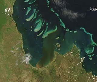
 2007 image from NASA's Terra satellite showing plumes of sediment flowing into the bay | |
 | |
| Location | |
| Country | Australia |
| State | Queensland |
| Region | Far North Queensland |
| District | Shire of Cook |
| Physical characteristics | |
| Length | 61 km (38 mi) |
| Basin features | |
| Tributaries | |
| • left | Normanby River, Bizant River, North Kennedy River, Marrett River |
Princess Charlotte Bay is a large bay on the east coast of Far North Queensland at the base of Cape York Peninsula, 350 km north northwest of Cairns. Princess Charlotte Bay is a part of the Great Barrier Reef Marine Park and it is a habitat for the dugong.
Reefs in the bay are described as pristine.[1] Barramundi habitat and associated wetlands exist in declared green zones which restrict commercial fishing.
- ^ "Run-off damages reefs, researcher". ABC News Online. Australian Broadcasting Corporation. 8 September 2005. Retrieved 10 June 2011.