| Providence Mountains | |
|---|---|
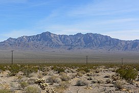
 Providence Mountains from the north | |
| Highest point | |
| Peak | Edgar Peak |
| Elevation | 7,162 ft (2,183 m) |
| Geography | |
location of Providence Mountains in California[1] | |
| Country | United States |
| State | California |
| Region(s) | Mojave National Preserve (Mojave Desert) |
| District | San Bernardino County |
| Range coordinates | 35°1′49″N 115°31′41″W / 35.03028°N 115.52806°W |
| Topo map | USGS Hayden |
Wikimedia Commons has media related to Providence Mountains.
The Providence Mountains are found in the eastern Mojave Desert of San Bernardino County, California, U.S. The range reaches an elevation of 7,162 feet (2,183 m) at Edgar Peak[2] and is home to the Mitchell Caverns Natural Preserve in the Providence Mountains State Recreation Area, and the Mojave National Preserve.
