Old Providence Island
Isla de Providencia Old Providence | |
|---|---|
 Satellite view of Providencia | |
 | |
| Coordinates: 13°20′56″N 81°22′29″W / 13.34889°N 81.37472°W | |
| Country | |
| Department | San Andrés, Providencia and Santa Catalina |
| Area | |
| • Total | 17.0 km2 (6.6 sq mi) |
| Elevation | 360 m (1,180 ft) |
| Population (2007) | |
| • Total | 5,011 |
| • Density | 290/km2 (760/sq mi) |
| Estimate | |
| Time zone | Colombia Time (COT) |
| • Summer (DST) | none |
| Languages | San Andrés–Providencia Creole, Spanish |

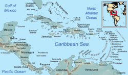
Isla de Providencia, historically Old Providence, and generally known as Providencia or Providence, is a mountainous Caribbean island that is part of the Colombian department of Archipelago of San Andrés, Providencia and Santa Catalina, or The Raizal Islands, and the municipality of Providencia and Santa Catalina Islands, lying midway between Costa Rica and Jamaica.
Providencia's maximum elevation is 360 metres (1,180 ft) above sea level. The smaller Santa Catalina Island to the northwest is connected by a 100-metre (330 ft) footbridge to its larger sister Providencia Island. Providencia Island has an area of 17 square kilometres (6.6 sq mi);[1] the two islands cover an area of 22 square kilometres (8.5 sq mi) and form the municipality of Santa Isabel, which had a population of 4,927 at the Census of 2005. The island is served by El Embrujo Airport, which the Colombian Government plans to expand in order to take international flights.
The island was the site of an English Puritan colony established in 1629 by the Providence Island Company, and was taken by Spain in 1641. Forts and cannons dating back hundreds of years can be found scattered all over Santa Catalina Island.
In November 2020, Hurricane Iota directly impacted the island. An estimated 98% of all infrastructure was destroyed from the impact, making it one of the worst and strongest tropical cyclones to impact Colombia.
- ^ Tiempo, Casa Editorial El (27 October 2012). "Providencia, el paraíso en 17 kilómetros cuadrados". El Tiempo (in Spanish). Retrieved 23 November 2019.
