Providensky District
Провиденский район | |
|---|---|
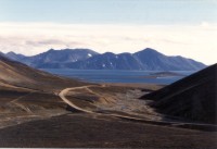
 Road to Novoye Chaplino in Providensky District | |
 Location of Providensky District in Chukotka Autonomous Okrug | |
| Coordinates: 64°27′N 173°15′W / 64.450°N 173.250°W | |
| Country | Russia |
| Federal subject | Chukotka Autonomous Okrug[1] |
| Established | April 25, 1957[2] |
| Administrative center | Provideniya[1] |
| Government | |
| • Type | Local government |
| • Head of Administration[3] | Sergey Shestopalov (acting)[3] |
| Area | |
| • Total | 26,800 km2 (10,300 sq mi) |
| Population | |
| • Total | 3,923 |
| • Estimate (January 2016)[6] | 3,714 |
| • Density | 0.15/km2 (0.38/sq mi) |
| • Urban | 50.2% |
| • Rural | 49.8% |
| Administrative structure | |
| • Inhabited localities[7] | 1 Urban-type settlements[8], 5 rural localities |
| Municipal structure | |
| • Municipally incorporated as | Providensky Municipal District[9] |
| • Municipal divisions[9] | 1 urban settlements, 3 rural settlements |
| Time zone | UTC+12 (MSK+9 |
| OKTMO ID | 77710000 |
| Website | http://www.provadm.ru |
Providensky District (Russian: Провиде́нский райо́н; Chukchi: Урэлӄуйым район, Urèlḳujym rajon; Yupik: Уӷрилӄуйым район) is an administrative[1] and municipal[9] district (raion), one of the six in Chukotka Autonomous Okrug, Russia. It is located in the northeast of the autonomous okrug, in the southern half of the Chukchi Peninsula with a northwest extension reaching almost to the Kolyuchinskaya Bay on the Arctic. It borders with Chukotsky District in the north, the Bering Sea in the east and south, and with Iultinsky District in the west. The area of the district is 26,800 square kilometers (10,300 sq mi).[4] Its administrative center is the urban locality (an urban-type settlement) of Provideniya.[1] Population: 3,923 (2010 Census);[5] 4,660 (2002 Census);[11] 9,778 (1989 Soviet census).[12] The population of Provideniya accounts for 50.2% of the district's total population.[5]
- ^ a b c d Law #33-OZ
- ^ Cite error: The named reference
Aboutwas invoked but never defined (see the help page). - ^ a b Official website of Providensky District. Local Self-Government of Providensky Municipal District Archived November 26, 2013, at the Wayback Machine
- ^ a b О муниципалитете – Провиденский городской округ
- ^ a b c Russian Federal State Statistics Service (2011). Всероссийская перепись населения 2010 года. Том 1 [2010 All-Russian Population Census, vol. 1]. Всероссийская перепись населения 2010 года [2010 All-Russia Population Census] (in Russian). Federal State Statistics Service.
- ^ Chukotka Autonomous Okrug Territorial Branch of the Federal State Statistics Service. Численность постоянного населения Чукотского автономного округа по муниципальным образованиям на 1 января 2016 года (in Russian)
- ^ Directive #517-rp
- ^ The count of urban-type settlements may include the work settlements, the resort settlements, the suburban (dacha) settlements, as well as urban-type settlements proper.
- ^ a b c Law #45-OZ
- ^ "Об исчислении времени". Официальный интернет-портал правовой информации (in Russian). June 3, 2011. Retrieved January 19, 2019.
- ^ Federal State Statistics Service (May 21, 2004). Численность населения России, субъектов Российской Федерации в составе федеральных округов, районов, городских поселений, сельских населённых пунктов – районных центров и сельских населённых пунктов с населением 3 тысячи и более человек [Population of Russia, Its Federal Districts, Federal Subjects, Districts, Urban Localities, Rural Localities—Administrative Centers, and Rural Localities with Population of Over 3,000] (XLS). Всероссийская перепись населения 2002 года [All-Russia Population Census of 2002] (in Russian).
- ^ Всесоюзная перепись населения 1989 г. Численность наличного населения союзных и автономных республик, автономных областей и округов, краёв, областей, районов, городских поселений и сёл-райцентров [All Union Population Census of 1989: Present Population of Union and Autonomous Republics, Autonomous Oblasts and Okrugs, Krais, Oblasts, Districts, Urban Settlements, and Villages Serving as District Administrative Centers]. Всесоюзная перепись населения 1989 года [All-Union Population Census of 1989] (in Russian). Институт демографии Национального исследовательского университета: Высшая школа экономики [Institute of Demography at the National Research University: Higher School of Economics]. 1989 – via Demoscope Weekly.

