| Province of Hohenzollern Hohenzollernsche Lande (German) | |||||||||||
|---|---|---|---|---|---|---|---|---|---|---|---|
| Province of Prussia | |||||||||||
| 1850–1946 | |||||||||||
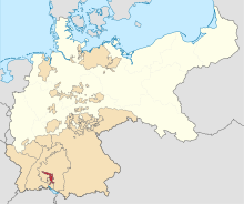
 The Hohenzollern Lands (red), within the Kingdom of Prussia (white), within the German Empire (white + light yellow) | |||||||||||
| Capital | Sigmaringen | ||||||||||
| Area | |||||||||||
| • Coordinates | 48°05′N 9°13′E / 48.083°N 9.217°E | ||||||||||
• 1939 | 1,142 km2 (441 sq mi) | ||||||||||
| Population | |||||||||||
• 1939 | 73,844 | ||||||||||
| History | |||||||||||
• Established | 1850 | ||||||||||
• Disestablished | 1946 | ||||||||||
| |||||||||||
| Today part of | Baden-Württemberg | ||||||||||
The Province of Hohenzollern (German: Hohenzollernsche Lande, Hohenzollern Lands) was a district of Prussia from 1850 to 1946. It was located in Swabia, the region of southern Germany that was the ancestral home of the House of Hohenzollern, to which the kings of Prussia belonged.
The Hohenzollern Lands were formed in 1850 from two principalities that had belonged to members of the Catholic branch of the Hohenzollern family. They were united to create a unique type of administrative district (Regierungsbezirk) that was not a true province[1] – a Regierungsbezirk was normally a part of a province – but that had almost all the rights of a Prussian province.[2] The Hohenzollern Lands lost their separate identity in 1946 when they were made part of the state of Württemberg-Hohenzollern following World War II.
- ^ Lilla, Joachim. "Die administrativen Beziehungen der Hohenzollernschen (Hohenzollerischen) Lande zur Rheinprovinz" [The Administrative Relations of the Hohenzollern Lands to the Rhine Province (1852 to 1945)]. Portal Rheinische Geschichte (in German).
- ^ Romeyk, Horst (1985). Verwaltungs- und Behördengeschichte der Rheinprovinz 1914–1945 [History of Administration and Public Authorities of the Rhine Province 1914–1945] (in German). Düsseldorf: Droste Verlag. pp. 123 ff.

