| Prut Porata, Pyretus | |
|---|---|
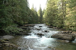
 Prut River near Hoverla, Ivano-Frankivsk Oblast | |
 Map of the Prut River | |
| Location | |
| Country | |
| Oblasts/ Counties/ Districts | Ukraine: Romania: Moldova: |
| Cities | |
| Physical characteristics | |
| Source | Carpathian Mountains |
| • location | Mt. Hoverla, Ivano-Frankivsk O., Ukraine |
| Mouth | Danube |
• location | Giurgiulești, Romania/Moldova |
• coordinates | 45°28′8″N 28°12′28″E / 45.46889°N 28.20778°E |
| Length | 953 km (592 mi) |
| Basin size | 27,540 km2 (10,630 sq mi) |
| Discharge | |
| • location | mouth |
| • average | 110 m3/s (3,900 cu ft/s) |
| Basin features | |
| Progression | Danube→ Black Sea |
| Tributaries | |
| • right | Cheremosh, Jijia |

| |
| Official name | Prut River Headwaters |
| Designated | 20 March 2019 |
| Reference no. | 2395[1] |
The Prut (also spelled in English as Pruth; Romanian pronunciation: [prut], Ukrainian: Прут) is a river in Eastern Europe. It is a left tributary of the Danube,[2][3] and is 953 km (592 mi) long.[4] Part of its course forms Romania's border with Moldova and Ukraine.
- ^ "Prut River Headwaters". Ramsar Sites Information Service. Retrieved 10 September 2019.
- ^ "Planul național de management. Sinteza planurilor de management la nivel de bazine/spații hidrografice, anexa 7.1" (PDF, 5.1 MB). Administrația Națională Apele Române. 2010. pp. 1022–1024.
- ^ Atlasul cadastrului apelor din România. Partea 1 (in Romanian). Bucharest: Ministerul Mediului. 1992. pp. 445–463. OCLC 895459847. River code: XIII.1
- ^ O. Islam; A. Savin; T. Belous (December 2006). "Prut River Basin Management - Case Study" (PDF). Centre for Environmentally Sustainable Economic Policy. p. 15.