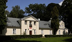
Przysucha | |
|---|---|
 Dembiński manor | |
| Coordinates: 51°22′N 20°37′E / 51.367°N 20.617°E | |
| Country | |
| Voivodeship | Masovian |
| County | Przysucha |
| Gmina | Przysucha |
| Established | 15th century |
| Town rights | 1710 |
| Government | |
| • Mayor | Tadeusz Tomasik |
| Area | |
• Total | 6.98 km2 (2.69 sq mi) |
| Population (2006) | |
• Total | 6,245 |
| • Density | 890/km2 (2,300/sq mi) |
| Time zone | UTC+1 (CET) |
| • Summer (DST) | UTC+2 (CEST) |
| Postal code | 26-400 |
| Area code | +48 48 |
| Car plates | WPY |
| Website | przysucha.pl |
| Part of a series on |
| Peshischa Hasidism |
|---|
| Rebbes & Disciples |
Przysucha [pʂɨˈsuxa] is a town in south-central Poland. Located in historic Lesser Poland, it is part of the Masovian Voivodeship, about 100 km southwest of Warsaw and 40 km west of Radom. It is the capital of Przysucha County, and the town 6,762 inhabitants (2004). Its name in Yiddish is פּשיסכע or פשיסחא or פשיסכא (pronounced: Pshiskhe). In the past, it was home to a number of Hasidic Rabbis, such as The Holy Jew and Simcha Bunim of Peshischa.
Przysucha is located on the Radomka river, along national road nr. 12 (which in the future will make Expressway S12). Rail station Przysucha is located in the village of Skrzyńsko, on the line from Radom to Łódź.

