This article includes a list of general references, but it lacks sufficient corresponding inline citations. (August 2014) |
Pueblo of Isleta | |
|---|---|
 Location of the Pueblo of Isleta | |
| Country | United States |
| State | New Mexico |
| County | Bernalillo |
| Website | Pueblo of Isleta |
Isleta Pueblo (Shiewhibak) | |
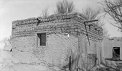
 Ruins at Isleta Pueblo | |
| Location | U.S. 85, Isleta, New Mexico |
|---|---|
| Coordinates | 34°54′31″N 106°41′30″W / 34.90861°N 106.69167°W |
| Area | 211,000 acres (85,000 ha) |
| Built | 1613 |
| Architectural style | Pueblo Style |
| NRHP reference No. | 75001162[1] |
| NMSRCP No. | 247 |
| Significant dates | |
| Added to NRHP | September 5, 1975 |
| Designated NMSRCP | May 5, 1972[2] |


Pueblo of Isleta (Southern Tiwa: Shiewhibak [ʃiexʷibʔàg], Western Keres: Dîiw'a'ane [tîːwˀa̤ʔane]; Navajo: Naatoohó [nɑ̀ːtxòːxó]) is an unincorporated community and Tanoan pueblo in Bernalillo County, New Mexico, United States, originally established in the c. 14th century. The Southern Tiwa name of the pueblo is Shiewhibak (Shee-eh-whíb-bak)[a] meaning "a knife laid on the ground to play whib",[4] a traditional footrace.[5] Its people are a federally recognized tribe.
Pueblo of Isleta is located in the Middle Rio Grande Valley, 13 miles (21 km) south of Albuquerque. It is adjacent to and east of the main section of Laguna Pueblo. The pueblo was built on a knife-shaped lava flow running across an ancient Rio Grande channel.[6] The Isleta Pueblo Historic District is listed on the National Register of Historic Places.
On January 15, 2016, the tribe's officials and federal government representatives held a ceremony to mark the government's taking into federal trust some 90,151 acres of land (140 square miles) which the Pueblo had then purchased. It enlarged their communal territory by 50%. The tribe had worked for more than 20 years to acquire this land, once part of their ancestral homeland. It was the largest acquisition of this kind handled under the Barack Obama administration.[7]
- ^ "National Register Information System". National Register of Historic Places. National Park Service. March 13, 2009.
- ^ "New Mexico State and National Registers". New Mexico Historic Preservation Commission. Archived from the original on September 22, 2017. Retrieved October 16, 2016.
- ^ Aleiss, Angela (October 12, 2017). "Is This Really the Legendary Cochise?". IndianCountryToday.com. Archived from the original on November 28, 2018. Retrieved November 28, 2018.
- ^ Frances Densmore. Music of Acoma, Isleta, Cochiti, and Zuñi Pueblos. Washington: U.S. G.P.O., 1957, p.1.
- ^ Lummis, Charles (1910). Pueblo Indian Folk-Stories. New York: Century Co. p. 252:1. Archived from the original on January 19, 2013. Retrieved November 18, 2012.
An ancient game in which the players race many miles, kicking a small stick ahead of them. They must touch it only with their toes.
- ^ Lummis, Charles (1910). Pueblo Indian Folk-Stories. New York: Century Company. p. 252:1. Archived from the original on January 19, 2013. Retrieved November 18, 2012.
- ^ Mary Annette Pember, "Isleta Pueblo Score Largest Parcel of Trust Land in Single Application" Archived 2016-01-23 at the Wayback Machine, Indian Country Today, 20 January 2016, accessed 20 January 2016
Cite error: There are <ref group=lower-alpha> tags or {{efn}} templates on this page, but the references will not show without a {{reflist|group=lower-alpha}} template or {{notelist}} template (see the help page).


