 Highway 113 | ||||
|---|---|---|---|---|
| Ruta 113 | ||||
| Route information | ||||
| Maintained by Puerto Rico DTPW | ||||
| Length | 19.8 km[1][2] (12.3 mi) | |||
| Existed | 1953[3]–present | |||
| Major junctions | ||||
| West end | ||||
| ||||
| East end | ||||
| Location | ||||
| Country | United States | |||
| Territory | Puerto Rico | |||
| Municipalities | Isabela, Quebradillas, Camuy | |||
| Highway system | ||||
| ||||
Puerto Rico Highway 113 (PR-113) is a rural road that travels from Isabela, Puerto Rico to Quebradillas. It begins at downtown Isabela and ends at its intersection with PR-119 near Guajataca Lake.[4][5]
-
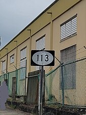 Eastbound sign for PR-113 in Isabela
.jpg)
- ^ Cite error: The named reference
google PR-113Wwas invoked but never defined (see the help page). - ^ Cite error: The named reference
google PR-113Ewas invoked but never defined (see the help page). - ^ "Quebradillas, Memoria Núm. 62" (PDF). Puerto Rico Planning Board (in Spanish). 1955. Retrieved 4 August 2020.
- ^ National Geographic Maps (2011). Puerto Rico (Map). 1:125,000. Adventure Map (Book 3107). Evergreen, Colorado: National Geographic Maps. ISBN 978-1566955188. OCLC 756511572.
- ^ "Tránsito Promedio Diario (AADT)". Transit Data (Datos de Transito) (in Spanish). DTOP PR. p. 64. Archived from the original on 1 April 2019.