  Highway 6685 | ||||
|---|---|---|---|---|
| Ruta 6685 | ||||
| Route information | ||||
| Maintained by Puerto Rico DTPW | ||||
| Length | 11.9 km[1] (7.4 mi) | |||
| Major junctions | ||||
| South end | ||||
| ||||
| North end | ||||
| Location | ||||
| Country | United States | |||
| Territory | Puerto Rico | |||
| Municipalities | Ciales, Manatí | |||
| Highway system | ||||
| ||||
Puerto Rico Highway 6685 (PR-6685) is a rural highway in Puerto Rico that runs south to north, connecting the towns of Ciales and Manatí on Puerto Rico's north coast.[2] It runs slightly parallel to Puerto Rico Highway 149 until it ends at Puerto Rico Highway 2 in Manatí.[3] It has a junction with PR-149 in Ciales and with Puerto Rico Highway 642 in Río Arriba Saliente barrio, in Manatí.[4]
- Puerto Rico Highway 6685 by municipality
-
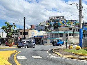 Northern terminus at PR-2 junction in downtown Manatí, looking south
 -
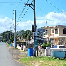 Heading north between Cordillera and Hato Viejo barrios in Ciales

.jpg)
- ^ Cite error: The named reference
googlewas invoked but never defined (see the help page). - ^ "PR-6685, Ciales, Puerto Rico". geoview.info. Retrieved 28 February 2020.
- ^ "PR-6685, Manatí, Puerto Rico". geoview.info. Retrieved 28 February 2020.
- ^ National Geographic Maps (2011). Puerto Rico (Map). 1:125,000. Adventure Map (Book 3107). Evergreen, Colorado: National Geographic Maps. ISBN 978-1566955188. OCLC 756511572.