Pukekohe | |
|---|---|
Town | |
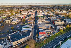
 Pukekohe CBD, as seen from above | |
 | |
| Coordinates: 37°12′S 174°54′E / 37.200°S 174.900°E | |
| Country | New Zealand |
| Region | Auckland Region |
| Ward | Franklin ward |
| Board | Franklin Local Board |
| Electorates | |
| Government | |
| • Territorial authority | Auckland Council |
| Area | |
• Town | 31.03 km2 (11.98 sq mi) |
| Population (June 2024)[2] | |
| • Urban | 28,000 |
| Postcode | 2120 |
| Area code | 09 |
Pukekohe is a town in the Auckland Region of the North Island of New Zealand. Located at the southern edge of the Auckland Region, between the southern shore of the Manukau Harbour and the mouth of the Waikato River. The hills of Pukekohe and nearby Bombay Hills form the natural southern limit of the Auckland region. Pukekohe is located within the political boundaries of the Auckland Council, following the abolition of the Franklin District Council on 1 November 2010.
With a population of 28,000 (June 2024),[2] Pukekohe is the 24th largest urban area in New Zealand, and the third largest in the Auckland Region behind Auckland itself and Hibiscus Coast.
- ^ Cite error: The named reference
Areawas invoked but never defined (see the help page). - ^ a b "Aotearoa Data Explorer". Statistics New Zealand. Retrieved 26 October 2024.