Purmerland | |
|---|---|
Village | |
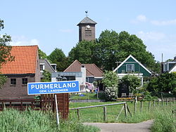
 View on Purmerland | |
| Coordinates: 52°29′N 4°56′E / 52.483°N 4.933°E | |
| Country | Netherlands |
| Province | North Holland |
| Municipality | Landsmeer |
| Area | |
• Total | 3.28 km2 (1.27 sq mi) |
| Elevation | −1.3 m (−4.3 ft) |
| Population (2021)[1] | |
• Total | 355 |
| • Density | 110/km2 (280/sq mi) |
| Time zone | UTC+1 (CET) |
| • Summer (DST) | UTC+2 (CEST) |
| Postal code | 1451[1] |
| Dialing code | 0299 |
Purmerland () is a village of 395 (January 2007)[3] in the municipality of Landsmeer, North Holland, the Netherlands. It is located just north of Den Ilp and just south of the housing estate of Weidevenne, part of the city of Purmerend. It is directly connected to both of these as Purmerland, like Den Ilp and Landsmeer is mainly characterised by ribbon building along the main road. Purmerland was part of the Free and high Lordship of Purmerend, Purmerland and Ilpendam.
- ^ a b c "Kerncijfers wijken en buurten 2021". Central Bureau of Statistics. Retrieved 30 April 2022.
- ^ "Postcodetool for 1451MC". Actueel Hoogtebestand Nederland (in Dutch). Het Waterschapshuis. Retrieved 30 April 2022.
- ^ Landsmeer Municipality website re Population figures Archived 2007-12-05 at the Wayback Machine

