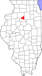
Putnam County | |
|---|---|
 Putnam County Courthouse, Hennepin | |
 Location within the U.S. state of Illinois | |
 Illinois's location within the U.S. | |
| Coordinates: 41°12′N 89°17′W / 41.2°N 89.28°W | |
| Country | |
| State | |
| Founded | 1825 |
| Named for | Israel Putnam |
| Seat | Hennepin |
| Largest village | Granville |
| Area | |
• Total | 172 sq mi (450 km2) |
| • Land | 160 sq mi (400 km2) |
| • Water | 12 sq mi (30 km2) 7.0% |
| Population (2020) | |
• Total | 5,637 |
• Estimate (2023) | 5,561 |
| • Density | 33/sq mi (13/km2) |
| Time zone | UTC−6 (Central) |
| • Summer (DST) | UTC−5 (CDT) |
| Congressional districts | 14th, 16th |
| Website | www |
Putnam County is the least extensive county in the U.S. state of Illinois. According to the 2020 census, it had a population of 5,637.[1] The county seat is Hennepin.[2] The county was formed in 1825 out of Fulton County and named after Israel Putnam,[3] who was a general in the American Revolution. Putnam County is part of the Ottawa, IL Micropolitan Statistical Area.
- ^ "Putnam County, Illinois". United States Census Bureau. Retrieved June 10, 2023.
- ^ "Find a County". National Association of Counties. Retrieved June 7, 2011.
- ^ "About Putnam County". Putnam County, Illinois. Retrieved July 27, 2012.