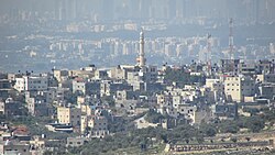
Qibya | |
|---|---|
| Arabic transcription(s) | |
| • Arabic | قبية |
 Qibya | |
Location of Qibya within Palestine | |
| Coordinates: 31°58′39″N 35°00′35″E / 31.97750°N 35.00972°E | |
| Palestine grid | 151/153 |
| State | State of Palestine |
| Governorate | Ramallah and al-Bireh |
| Government | |
| • Type | Municipality |
| • Head of Municipality | Fahmi Makhtub |
| Area | |
• Total | 16,485 dunams (16.5 km2 or 6.4 sq mi) |
| Population (2017)[1] | |
• Total | 6,090 |
| • Density | 370/km2 (960/sq mi) |
| Name meaning | Domed[2] |
Qibya (Arabic: قبية) is a Palestinian village in the West Bank, located 30 kilometers (19 mi) northwest of Ramallah and exactly north of the large Israeli city of Modi'in. It is part of the Ramallah and al-Bireh Governorate, and according to the Palestinian Central Bureau of Statistics, it had a population of approximately 6,090 in 2017.[1]
The village is notorious for being the site of the 1953 Qibya massacre.
- ^ a b Preliminary Results of the Population, Housing and Establishments Census, 2017 (PDF). Palestinian Central Bureau of Statistics (PCBS) (Report). State of Palestine. February 2018. pp. 64–82. Retrieved 2023-10-24.
- ^ Palmer, 1881, p. 237
