Qinggil County
Chinggil, Qinghe, Ch'ing-ho | |
|---|---|
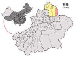
 Location of Qinggil County (pink) in Altay Prefecture (yellow) and Xinjiang | |
| Coordinates: 46°37′N 90°25′E / 46.617°N 90.417°E | |
| Country | China |
| Autonomous region | Xinjiang |
| Prefecture | Altay |
| County seat | Qinggil |
| Township-level divisions | 5 towns 3 townships[1][2] |
| Area | |
| • Total | 15,579.5 km2 (6,015.3 sq mi) |
| Elevation | 1,220 m (4,000 ft) |
| Population (2020)[5] | |
| • Total | 61,680 |
| • Density | 4.0/km2 (10/sq mi) |
| Ethnic groups | |
| • Major ethnic groups | Kazakh |
| Time zone | UTC+8 (China Standard[a]) |
| Postal code | 836200 |
| Website | xjqh |
| Qinggil County | |||||||||||
|---|---|---|---|---|---|---|---|---|---|---|---|
| Chinese name | |||||||||||
| Simplified Chinese | 青河县 | ||||||||||
| Traditional Chinese | 青河縣 | ||||||||||
| |||||||||||
| Uyghur name | |||||||||||
| Uyghur | چىڭگىل ناھىيىسى | ||||||||||
| |||||||||||
| Kazakh name | |||||||||||
| Kazakh | شىڭگىل اۋدانى Шіңгіл ауданы Şıñgıl audany | ||||||||||
Qinggil County[6][7][8] (Uyghur), also Chinggil County,[9][10][11] Qinghe County, is a county of Altay Prefecture in northeastern Xinjiang, China, bordering Bayan-Ölgii Province and Khovd Province in Mongolia to the east. It has an area of 15,722 km2 (6,070 sq mi) with a population of 60,000[when?]. Qinghe was the site of a meteorite impact in 1898 and a Mongolian–Chinese border clash in the spring of 1944.
- ^ Cite error: The named reference
statsqinggilwas invoked but never defined (see the help page). - ^ Cite error: The named reference
govqinggilwas invoked but never defined (see the help page). - ^ 地理位置. 青河县人民政府 (in Simplified Chinese). 2020-06-04. Archived from the original on 22 November 2020. Retrieved 22 November 2020.
- ^ Cite error: The named reference
xzqhqinggilwas invoked but never defined (see the help page). - ^ Xinjiang: Prefectures, Cities, Districts and Counties
- ^ Ministry of Housing and Urban-Rural Development (2010). 建筑抗震设计规范 [GB50011-2010: Code for Seismic Design of Buildings] (in English and Simplified Chinese). Beijing: China Architecture & Building Press. p. 203 – via Google Books.
Qinggil County
- ^ Ping Cheng (1989). Xinjiang: The Land and the People. p. 163. ISBN 9787800050787.
- ^ Qiao Long (6 February 2019). Luisetta Mudie (ed.). "Chinese Officials Force Muslims to Drink, Eat Pork At Festival". Translated by Luisetta Mudie. Archived from the original on 7 February 2019. Retrieved 15 November 2020.
Altay's Qinggil (in Chinese, Qinghe) county
- ^ "Annual Report on International Religious Freedom". 2009. p. 7.
- ^ "Xinjiang". Government Publishing Office. 10 October 2011. p. 22.
- ^ "Interview Kazakh from China fights to free his family". 24 September 2020. Archived from the original on 29 September 2020. Retrieved 21 November 2020.
Chinggil County, in Xinjiang's Ili Kazakh Autonomous Prefecture
Cite error: There are <ref group=lower-alpha> tags or {{efn}} templates on this page, but the references will not show without a {{reflist|group=lower-alpha}} template or {{notelist}} template (see the help page).


