| Queanbeyan New South Wales | |||||||||||||||
|---|---|---|---|---|---|---|---|---|---|---|---|---|---|---|---|
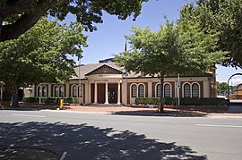
 Queanbeyan Council Chambers | |||||||||||||||
| Coordinates | 35°21′12″S 149°14′03″E / 35.35333°S 149.23417°E | ||||||||||||||
| Population | 37,511 (2021 census)[1] | ||||||||||||||
| • Density | 210/km2 (540/sq mi) | ||||||||||||||
| Established | 1838 | ||||||||||||||
| Elevation | 576 m (1,890 ft) | ||||||||||||||
| Area | 173 km2 (66.8 sq mi) | ||||||||||||||
| Time zone | AEST (UTC+10:00) | ||||||||||||||
| • Summer (DST) | AEDT (UTC+11:00) | ||||||||||||||
| Location |
| ||||||||||||||
| LGA(s) | Queanbeyan-Palerang Regional Council | ||||||||||||||
| County | Murray | ||||||||||||||
| Parish | Queanbeyan | ||||||||||||||
| State electorate(s) | Monaro | ||||||||||||||
| Federal division(s) | Eden-Monaro | ||||||||||||||
 | |||||||||||||||
| |||||||||||||||
Queanbeyan (/ˈkwiːnbiən/ KWEEN-bee-ən) is a city in south-eastern New South Wales, Australia, located adjacent to the Australian Capital Territory in the Southern Tablelands region. Located on the Queanbeyan River, the city is the council seat of the Queanbeyan-Palerang Regional Council. At the 2021 census, the Queanbeyan part of the Canberra–Queanbeyan built-up area had a population of 37,511.[1]
Queanbeyan's economy is based on light construction, manufacturing, service, retail and agriculture. Canberra, Australia's capital, is located 15 kilometres (9 miles) to the west, and Queanbeyan is a commuter town. The word Queanbeyan is the anglicised form of Quinbean, an Aboriginal word meaning "clear waters"[citation needed].
